I just got a new pair of trail shoes from
The Clymb and was anxious to try them out on some trails. I got the
Montrail Rockridge and although the Mountain Masochists (not just because I was running that race soon) were my first choice, I was happy to get new shoes for ~$50 including shipping!
Unintentionally I started covering the
Mountain to Sea Trail (MST) in this part of the state by going on some longer fun runs in the past year or two. With a couple long runs I had all 40+ miles of trail covered from Grandfather Mountain (sect 13.3) to Deep Gap (end of sect 14). And with an 11+ mile birthday run this year I had a good portion of section 17 (Brinegar Cabin to start of 17.1) covered as well. Suddenly the thought of linking up Stone Mountain to Grandfather Mountain seemed possible and like something I could do without inconveniencing the family too much with long drives or waiting for me to finish a run. I haven't been on sections 15 (Deep Gap to Horse Gap - 15.8mi) or 16 (Horse Gap to Laurel Springs - 15.2mi) and with the close proximity to my in-laws cabin I set out for one of these portions. Not being able to coordinate rides and realizing I should be taking it easy to see how my legs had recovered from
yesterdays race, I decided an out and back would be the smart move and headed for Horse Gap to check out the first portion of section 16.

I've probably said it somewhere in this blog before but if you plan to spend any time on the MST then you have to check out
Art's Hiking Maps. Although not officially endorsed by the MST (probably something political) these maps are amazing and give great detail and have proved to be a lifesaver more than once (luckily only figuratively).
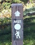
I found a place to park just across the road from the trailhead (by the Horse Gap sign) and looked for the familiar and (to me) welcoming trail marker with the white dot above a hiker. This portion started climbing quickly and I smartly proceeded to power hike on instead of running and testing the legs right away. I really did little research on this portion so I didn't know what to expect. I have one rule when out on these runs on the MST and its to take my time and enjoy God's creation. I usually try to bring a camera and if I see a side trail, as long as it looks like it might lead somewhere 'cool', I'll take it. Around one half mile into the run I saw one of these trails and was gifted with one of the best surprise views I've had on a run like this. I didn't know it but I had found 'Jumping Off Rock' and its amazing view of the the surrounding mountains to the East. I'll let pictures (and video if I get it uploaded) show what my words wouldn't be able to justice.

This portion would prove to be the high point literally (nearby trail ~3,200') and figuratively as the rest of the trail didn't have nearly the same views. The MST loosely followed the BRP (Blue Ridge Parkway) with some portions running on the actual parkway through this section. Farms, fields and some forested sections dominated this trail and the only other place of note was the
Northwest Trading Post about 3 miles in (BRP MP258). The surfaces ranged from soft dirt trail, gravel road, paved BRP, some technical rocky portions and soft fields/meadows. I felt pretty good and could have kept going but because of time constraints I pushed it as long as I could and turned back just after Bare Creek Rd a little over 5 miles in. Because I'm not generally a big fan of running on roads (especially with my new trail shoes) I was happy to find one segment where the trail actually was worn into the field just below the road instead of running along the road (as I did on the way out). Partly due to trying to get back quicker and partly because I get bored at one speed I decided to pickup the pace a bit on the way back and ran the final mile (minus another stop at Jumping Off Rock) in low 7 minute pace.
My new shoes performed well but I definitely feel like they have a lot more cushioning (and protection?) than I was used to. I purposefully tried to step on random rocks on the gravel road portions instead of running in the smooth tread patterns and maybe it was the rockplate but I didn't notice the rocks much and certainly didn't feel them poking through. I don't know what it is but these do feel like they run a little bigger than my usual shoe (Adidas Kanadia TRs) but the fit upon further review the fit seems to be very similar. There is just something about these shoes that feel kind of like boats in comparison. I look forward to breaking these shoes in a little and hopefully taking them with me on my journey through the mountains of VA in a few weeks!
 |
| On the Parkway somewhere around MP257 |
Overall this was a great shakeout run and I had some expected soreness but felt good overall. I'm really excited more than anything that I found a really cool, and easily accessible, spot (Jumping Off Rock) for me to share with the family. Note... the MST passes through the overlook with a marked trail to Jumping Off Rock coming from the other way so you don't have to park on the side of the road at Horse Gap. They are both about .5mi in and the hike from the overlook probably has a bit less elevation gain. Now 'only' about 10 more miles on section 16 and I can cross that one off my list.
 |
| Jumping Off Rock panoramic photo |
 |
| This woolly worm predicts a mild winter? |
 |
| Start of Section 16 (trail is just across BRP to left of picture) |

 I've probably said it somewhere in this blog before but if you plan to spend any time on the MST then you have to check out Art's Hiking Maps. Although not officially endorsed by the MST (probably something political) these maps are amazing and give great detail and have proved to be a lifesaver more than once (luckily only figuratively).


